| Artwork | Index | Editorial Writing | |
| Books | About | Links |
| Mary Heebner |
|
Santa Barbara Magazine |
by Mary Heebner photos by Macduff Everton |
|
|
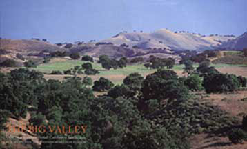
From San Marcos Pass Road, the strand of Channel Islands is partly visible, wreathed in a boa of low clouds beyond the fog-socked ocean. Highway 154 rises out of the Goleta foothills and cuts through ancient oyster beds, proof positive of this mountainÍs watery gestation, an origin that we too share. The winding road skirts mirror-bright Lake Cachuma. During cycles of drought the lake, created when the dam was completed in 1953, reveals too much of its pastoral underpinnings. Then a wet cycle brings coveted rain, tipping balance once again. Cresting the hill, a valley of small peaks cap like an agitated sea in the distance. Made from sediments that formed underwater, the Matilija, Cozy Dell, Juncal and Coldwater formations are the poetic names given this artistÍs palette of earth colors. As the highway opens onto Santa Ynez, it sweeps in larger arcs through rolling, camel-colored hills, redolent with the malt and honey aroma of savanna grasses. This is unmistakably the Golden State. The entire Santa Ynez Valley is one enormous watershed bound by the San Rafael and Santa Ynez Mountains, extending, as the river traverses the valley, all the way to the sea at Surf. |
|
Space abounds beneath a blue-hot sky, in this quintessential Californian landscape. The majestic valley oaks, with languid limbs that reach all the way to the ground, and canopies as large as a living room, give shelter and shade to birds, cattle, horses, and picnickers alike. A place this sublime, and this old, has absorbed continual waves of immigration, of flora and fauna and of people. The missions brought the biggest changes, introducing cattle, for their currency of trade was in tallow and hide. So alfalfa was planted on the flats, where the oaks grow best. Grapes for wine, and wheat for bread. At one time this valley was closed-canopy forest. However, who could resist working land this fertile? First, a half dozen Mexican land grants divvied up the valley. By the mid-1800's ranching was in its heyday. Then in 1863, on the heels of a winter of torrential rains that overwhelmed the land, came the Great Drought. The tremendous oaks were felled, their tannic leaves a desperate fodder for the starving cattle, and still 90% of the herds were lost. Radically, the landscape changed from oak forest to savanna grassland, and heaps of sun-bleached bones bespoke the demise of the baronial rancheros. In time, cereal crops and wine grapes delineated the contours of the rolling hills, cattle grazed and horses were bred. The Santa Ynez River is the lifeblood of this valley. For millennia it has delivered rich-as-gold sediment from the slowly eroding mountaintops. Ever since the ice sheets started melting 11,000 years ago, the river's seasonal floods and alluvial depositions have sculpted the land into a gentle, fertile Eden. Building and planting right up to the river's edge disregards this natural process. Cash crops and real estate are at risk whenever the loamy banks flood. But bulldozed flood channels that corset the river's natural meandering, force the powerful flow to etch deeply into the land, leaving ancient habitats in a literal rut, stanching the very quality that created the fertile valley in the first place. Before dams, cities and floodgates, the Santa Ynez River was one of the finest steelhead rivers in California. The Sedgewick Ranch Preserve below Figueroa Mountain is an intact watershed, from ridge to ridge, where Figueroa Creek spills off the mountain, unbridled. Survival is a game of strategy, adjusting and adapting to change. On a now treeless rise, a pair of red-tailed hawks hunts from a modern perch, the telephone pole. The Chumash, once skilled seafarers and successful traders with a sophisticated monetized market economy, have weathered massive changes, including repeated epidemics, dispossession of their land, and destructive acculturation. In 1844, around 35 years after the establishment of the Santa Inez Mission, Governor Manuel Micheltorena granted two Chumash, named Blas and Thomas, the property of Zanja de Cota. Ten years later the Santa Inez Indians were made to leave their homes at the mission and retreated to this site that remains today the location of the Santa Inez Chumash Indian Reservation. These days the Rez has swapped shell currency for gambling chips, and has again become a wealthy tribe. The Chumash Casino has its share of critics, however, tribal leaders say that unemployment is now zero, and health care and education are realizable dreams. This place moulds the people who've settled here, from Native Americans and Mission padres, to families seeking a simpler life of dirt-under-the-nails work and a hard-won dayÍs end. Nearly two centuries of ranching and farming has created tightly-knit clusters of five townships — Solvang, Buellton, Santa Ynez, Los Olivos and Ballard. Add to the mix a strong equestrian tradition and the post-1960's additions of fine restaurants, wineries, art galleries, theatres and bookstores, and Santa Ynez Valley emerges as a unique community of hearty yet sophisticated people. This infusion of urbanity has lured many to return who in their younger years fled this small inland cow town. This is the conundrum. Will future developments including more week-end ranchettes, trophy wineries perched incongruously on the windiest tip of a hilltop, and further subdivision of acreage, threaten the familial, agricultural character of the valley, or will the land once again sift out those with mere pretenses for a rural life? The fate of the valley has been hotly discussed for years. Articles dating from 1937 warn of the danger of extinction of the California white oak, and again in the 1970's a cover story on "the fight to save California's Shangri-la". A comprehensive community plan is in the offing, to guide future land use of the valley. The definitions of agricultural, residential and commercial land use will greatly determine whether this valley will go the way of other local paradises such as the once lush Goleta Valley. With CaliforniaÍs population supposedly doubling in 50 years, where are they all going to live? With the latest influx of newcomers, some planners are looking at European models in which homes are clustered around small city hubs, leaving the planted fields and the wild places beyond intact. Some landowners, aware that any zoning regulation is only as good as a 3 vote majority in the elected Board of Supervisors, have turned to the Land Trust to set up conservation easements on their property, insuring that their land will remain as they envision it, in perpetuity. For families wishing to preserve a quality of life for future generations, conservation easements are one way in which open spaces and substantial tax credits are gained for relinquishing development rights. At bottom, a well-honed sense of place coupled with a cultivated sense of stewardship, will do most to keep the soul of this valley vivid ©MARY HEEBNER 2001 |
|
|
|
|
|
|